Archive for the ‘Training Places’ Category

h1

Biking Plan 04 (Oji>Arakawa river>Hanno)

May 3, 2014

http://www.gmap-pedometer.com/?r=3244441

Need to add the map of the ride from Hanno.  Need to go back there to remember where to go..

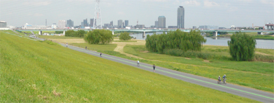
The Arakawa river is a great place to run and cycle. You can reach it from many different stations around Tokyo (Kita-senju, Adachiodai, Akabane, Oji and many others…).

Here is another idea of bike training course you can use along this river starting from Oji Station (on the Namboku line or the Keihin Tohoku line).
arakawa2

Change the picture of the Arakawa

STEP I: WARM UP (GET TO THE RIVER FROM THE STATION)
From: Oji Station (From point 1 to 3 on the map)
To: Arakawa River
Distance: 3.6km

ride01-ahttp://www.gmap-pedometer.com/?r=3208345

STEP II: WORK OUT
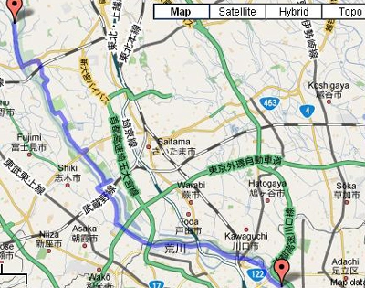
From: The 18km mark along the river. The first place we covered (Bike Plan 01) was aiming for the East direction until the 0km mark. THIS TIME, we will AIM FOR THE WEST DIRECTION.
To: pretty much as long as you want. This side of the bike course can go on forever and lead you anywhere depending on the path you take. Most of the course goes along the river and avoids any main road with traffic.
Distance: 71km (35.5km both way – go and come back)
bike02-b http://www.gmap-pedometer.com/?r=3220293

STEP III: COOL DOWN
From
: Arakawa River (from point 3 to 1 on the map)
To
: Oji Station
Distance
: 3.6km

ride01-ahttp://www.gmap-pedometer.com/?r=3208345

h1

Biking Plan 03 (Oi-Futo – Loop – 9.16km)

November 28, 2010


The Oi-Futo area is a popular spot for cyclists living in the Tokyo area. It’s not a particularly beautiful part of town (as it’s located in a container harbour near a port so you can imagine the scenary) but it offers a perfect training arena, and since the business is closed on each Sunday, you will benefit from an absolutely ZERO TRAFFIC ON SUNDAYS – which is a real luxary. This training spot is best for those of you who wish to train speed, do some interval training or ride is larger groups on wide open roads.

You can reach Oi-Futo area from many different stations (Shinagawa, Oimachi, Samezu, Shinagawa Seaside, Okeibajomae and others…) but keep in mind that they are all quite far from the actual spot. The most convenient way to access it is by bike.

The most popular course used is as follows (listed in red) but can be adjustable according to your preference:

OI-FUTO LOOP
Distance: 9.16km

Oi-futo Meeting Point

Oi-futo is a popular spot for speed training and for Triathlete to show off their TT Racing Bike

For those others not into Triathlon, they can enjoy riding in groups without worrying too much about the traffic


h1

Running Plan 08 (Tokyo – Arakawa River)

December 20, 2009


This running program is best for people living/working around the Arakawa river area (northern part of Tokyo downtown area) or for runners interested in doing relatively long runs and avoiding Tokyo’s traffic and pollution.

This running course (that can also be used for cycling) goes all along the river and has clear kilometer markers every 1km (from 0km mark to 35km mark) to help you evaluate the distance you cover during each one of your training sessions.

The most convenient stations to access the run path are:

– Minamisunamachi (Tozai line)
– Nishikasai (Tozai line)
– Higashiojima (Toei Shinjuku line)
– Funabori (Toei Shinjuku line)
– Hirai (JR Sobu Chuo line)
– Shinkoiwa (JR Sobu Chuo line)
– Yahiro (Keisei Oshiage Line)
– Yotsugi (Keisei Oshiage Line)
– Kanegafuchi (Tobu Line)
– Keiseisekiya (Keisei Line)
– Kita Senju (Chiyoda line, JR Joban Line, Hibiya Line)
– Adachiodai (Nippori-Toneri Liner)
– Oji (Keihin Tohoku Line, Namboku line)
– Oji Kamiya (Namboku line)
– Akabane (Keihin Tohoku Line, Saikyo Line, Shonan Shinjuku Line)
– Akabane Iwabuchi (Namboku line)
– KitaAkabane (Saikyo line)
– Ukimafunado (Saikyo line)
– Nishitakashimadaira (Mita line)
– Wakoshi (Yurakucho  line, Tobu Tojo Line)
– Nishiurawa (JR Musashino line)

http://www.gmap-pedometer.com/?r=3373122

h1

Trail Running Plan 01 – (Yamanashi – Nishizawa Keikoku Hiking Course)

November 14, 2009

P1180306

This trail run course is not easy to access but certainly worth the trip as it is by far one of the most beautiful hiking trail there is in Japan. If you love waterfalls and hiking trails with lots of ups and downs, and great scenery, you will be well served. Surrounded by countless waterfalls and sakura flowers during the spring cherry blossom season, you will be breath taken all along until your reach Nanatsugama-Godan-no-Taki (the last and biggest water fall of the trail). This last one ranks among the top 100 waterfalls of Japan.

TRAIL RUN COURSE DETAILS – 10KM COURSE

PART I
:
From: The car park near Point 1
(see map below)
To: The Nanatsugama-Godan-no-Taki waterfall near Point 18
Distance: 4km (Uphill)

PART II:
From:
The Nanatsugama-Godan-no-Taki waterfall near Point 18
To: The car park near point 1 (see map below)
Distance: 6Km (downhill)

The entire course will take you about 4 hours hiking / walking

P1180315The Nanatsugama-Godan-no-Taki waterfall

P1180349

On the way up to point 18

nishizawa-mapcourseCourse details (In Japanese)

Access:
The valley of Nishizawa  (Nishizawakeikoku / 西沢渓谷) is located by the Fuefuki River (笛吹川) in the north side of Yamanashi. It is a part of Chichibu-Tama-Kai National park (秩父多摩甲斐国立公園) where you can find a lot of other very beautiful similar trails and hiking courses.

nishizawa hiking course location
Get there by Car:
From Shinjuku station (Tokyo), follow the Chuo Expressway until Enzan station.  You will then need to head north on the road 38 until you reach the road 140 which will lead you directly to the trail starting point upper north.

Get there by Train:
From Shinjuku station (Tokyo), take the JR Chuo line until Enzan station. If you take an express train, you can get there in about 90 minutes (3190 Yen) . A local train will take you up to 150 minutes and you will need to do at least one transfer along the way (1460 Yen).

From Enzan station, you can ride the bus directly to Nishizawa Keikoku trail. The ride last about 1 hour and will cost you 1020 Yen each way. !!Attention!! There are only 6 bus rides available per day from December until April.
If you choose to take a cab, it will cost around 5,000 to 6,000 yen one way. It is worth considering if you are travelling in a group.

For more information on the trail and the location, please check the following link (in Japanese only):
http://www.city.yamanashi.yamanashi.jp/kanko/seeing/29.html

h1

Running Plan 07 (Tokyo – Tamagawa Daikoen)

November 12, 2009

tamagawa-daikoen-rsz

This running program is nearby the Tamagawa river further south of Futako Tamagawa station (Running Plan 03). You can easily reach this running course from Tamagawa station (Tamagawa line), Denenchofu (Toyoko line) and Yukigaya Ootsuka (Ikegami line).

The running course consist of either a 5km or 10km course where you will go through the small park called Tamagawa Daikoen (where you will enjoy a lot of ups and down, stairs and a nice view of the tamagawa river) and the famous and endless Tamagawa river. If you wish to train more your uphill running skills, we recommend you to run a few laps within the park and cut short your run section along the flat river.

tamagawa-run-5k

PLAN I – 5KM RUN:
From: Tamagawa station

Going through the Tamagawa Daikoen park and along the running river course.
To: Back to Tamagawa station
Distance: 5km (2 x 2.5km)

tamagawa-run-10k
PLAN I – 10KM RUN:
From: Tamagawa station

Going through the Tamagawa Daikoen park and along the running river course.
To: Back to Tamagawa station
Distance: 10km (2 x 5km)

h1

Running Plan 06 (Tokyo – Akasaka Palace)

November 4, 2009

Akasaka_Palace
This running program is very central and therefore very convenient for people living/working in downtown Tokyo mainly. It is easily accessible from Aoyama Iichome (Ginza line), Akasaka Mitsuke (Ginza line) Yotsuya (JR Sobu, JR Chuo and Marounouchi line) and Shinanomachi (JR Chuo line) stations.

The running course consist of 1 lap around the Akasaka Palace and includes a couple of challenging hills. Each lap covers around 3.3km.

running-plan06http://www.gmap-pedometer.com/?r=3299943

COURSE DETAILS:
1st Lap: 3.30km
2nd Lap:6.60km
3rd Lap:9.90km
4th Lap:12.00km
5th Lap:13.20km

6th Lap:16.50km
7th Lap: 19.90km

You can also extend your running course distance to 4.8km per lap by passing by the Shinanomachi running track (1.3km) which is just a few hundred meters from the Akasaka running course (see course description below).

running-plan06-2http://www.gmap-pedometer.com/?r=3299970

COURSE DETAILS:
1st Lap: 7.8km
2nd Lap:15.60km
3rd Lap:23.40km
4th Lap:31.20km

h1

Running Plan 05: (Tokyo – Kinuta Koen – Setagaya)

October 25, 2009

P1210313-banner

This running course is very convenient for people living/working in the Setagaya area. The closest stations to access Kinuta Koen park are: 1) Yoga (20 minutes walk), 2) Shoshigayaokura (via bus) and 3) Seijogakuenmae (via Bus). This park, which was open on April 1st 1957 and is as green as it gets. Close to the size of Yoyogi Koen, it stands out among parks in central Tokyo as having one of the largest expanses of grass lawn – which makes it a very enjoyable and diverse running course. A full lap of the course can allow you to cover around 4KM.

P1210259

run04-locationhttp://www.gmap-pedometer.com/?r=3278687

COURSE DETAILS:

From: Any Exit you come from
To:
That same Exit you started from.
Distance: 4 km per lap

1 LAP: 4km
2 LAPS: 8km
3 LAPS: 12km
4 LAPS: 18km
5 LAPS: 22km
6 LAPS: 26km
7 LAPS:30km

P1210263

For more information on “Kinuta Koen”, click on the link below:

kinutakoenmapFrom the Tokyo Metropolitan Government

h1

Running Plan 04: (Tokyo – Harajuku with the “Namban Rengo” Group)

October 21, 2009

namban_logoThis running program is for anyone interested in running with other fellow runners from Tokyo. The “Namban Rengo” running club gathers there every Wednesday evening for their Interval Training at the Oda Field. Anyone is welcome to join the group.
Their training session starts at 7:30pm sharp, so make sure to arrive at the latest at 7:20pm to have enough time to get ready before hand.

Access is a 10 minute walk from Harajuku Station. Lockers & showers available (free but lockers take a 100 yen coin, returnable). Cost of the workout is free. Just turn up and join in. All levels catered for.

oda-field-harajuku

About Namban Rengo:
Namban Rengo is an informal club for runners of all abilities. Most of them train to run in road races, trail races, ekidens and even triathlons. They are a social club with numerous informal events, training sessions and social gatherings.

To find out more, visit their official website at: http://www.namban.org/

h1

Running Plan 03 (Tokyo: FutakoTamagawa > River Course)

October 18, 2009

This running program is for people living/working around the Tamagawa river area. 7km south of Shibuya on the road 246, you can access this jogging course from the Futako-Tamagawa station train station (Den-en-Toshi Line, Oimachi Line). Just like the Arakawa river area, this path can go on forever. You will find below 3 running course suggestions covering distances of 10, 20 and 30km.

tamagawa-runners

COURSE DETAILS:

PLAN I – 10KM RUN:
From: South West of FutakoTamagawa station
(after the small bridge on the map below).
To: 5km mark
close to Izumi Tamagawa station – on the map and come back to the station.
Distance: 10km (2 x 5km)

futako-2x5kmhttp://www.gmap-pedometer.com/?r=3266332

PLAN II – 20KM RUN:
From: South West of FutakoTamagawa Station
(after the small bridge on the map below).
To: Turn around after the 10km
mark on the map to come back to the station.
Distance: 20km (2 x 10km)

futako-2x10kmhttp://www.gmap-pedometer.com/?r=3266334

PLAN III – 30KM RUN:
From: South West of FutakoTamagawa Station
(after the small bridge on the map below).
To: Turn around after the 15km
mark on the map to come back to the station.
Distance: 30km (2 x 15km)

futako-2x15km http://www.gmap-pedometer.com/?r=3266327

Note: This course is also very popular for cycling.

h1

Biking Plan 02 (Tokyo/Oji Arakawa river) 78.2KM

September 23, 2009

The Arakawa river is a great place to run and cycle. You can reach it from many different stations around Tokyo (Kita-senju, Adachiodai, Akabane, Oji and many others…).

Here is another idea of bike training course you can use along this river starting from Oji Station (on the Namboku line or the Keihin Tohoku line).

arakawa2

STEP I: WARM UP (GET TO THE RIVER FROM THE STATION)
From: Oji Station (From point 1 to 3 on the map)
To: Arakawa River
Distance: 3.6km

ride01-ahttp://www.gmap-pedometer.com/?r=3208345

STEP II: WORK OUT
From: The 18km mark along the river. The first place we covered (Bike Plan 01) was aiming for the East direction until the 0km mark. THIS TIME, we will AIM FOR THE WEST DIRECTION.
To: pretty much as long as you want. This side of the bike course can go on forever and lead you anywhere depending on the path you take. Most of the course goes along the river and avoids any main road with traffic.
Distance: 71km (35.5km both way – go and come back)

bike02-b http://www.gmap-pedometer.com/?r=3220293

STEP III: COOL DOWN
From
: Arakawa River (from point 3 to 1 on the map)
To
: Oji Station
Distance
: 3.6km

ride01-ahttp://www.gmap-pedometer.com/?r=3208345